
Admini, a 69-year-old patient at Siloam Hospital in Manado, was simply sitting and drinking tea when the floor began to move. For a moment, she thought nothing of it.
Then she heard a child scream for everyone to hurry and get down. Within minutes, doctors and nurses were frantically evacuating patients. They set up makeshift treatment areas outside in the open and inside parked vehicles.
Patients huddled together, some confined to wheelchairs, as they tried to process the shock.
A powerful 7.4-magnitude earthquake struck the Northern Molucca Sea early Thursday, terrifying residents across eastern Indonesia. The tremor killed at least one person, crushed by collapsing building debris, and triggered a regional tsunami warning that sent thousands fleeing toward higher ground.
The Science of the Strike
The United States Geological Survey (USGS) recorded the earthquake at 06:48 local time (22:48 GMT). It originated at a shallow depth of 35 kilometres, though early estimates had placed it much closer to the surface at just 10 kilometres.
Seismologists pinpointed the epicentre roughly 127 kilometres west-north-west of Ternate, a volcanic island in Indonesia’s North Maluku province.
Reuters initially reported a 7.6 magnitude, but the USGS confirmed the final figure as 7.4. The epicentre was located roughly 580 kilometres south of the Philippine coast and 1,000 kilometres away from Sabah, Malaysia.
Panic in the Streets
The shaking lasted between 10 and 20 seconds, but for the people living along the coast, it felt much longer.
In central Manado, a city of 450,000 people, journalist Isvara Safitri watched the furniture in her room shake violently. She told reporters that the tremors made her head feel dizzy, calling it the strongest earthquake she had experienced in the past six years. Even the paved roads outside her house vibrated.
Further east in Ternate, a city home to roughly 205,000 people, the scene was chaotic. Budi Nurgianto said his walls vibrated for what felt like more than a minute. When he rushed out into the street, he found a crowd of panicked neighbors.
Nurgianto told AFP that he even saw some people leaving their houses without finishing their showers.
In Bitung, a coastal city on the north-eastern edge of Sulawesi, Yayuk Oktiani was at the local market when the tremors hit. Stores suddenly lost power. As the tremors intensified, shoppers dropped their items and ran.
Oktiani ran straight toward her child’s school, which sits dangerously close to the sea. When she reached the school, teachers were already sending children home with their parents.
A Tsunami Threat That Faded
The shaking had barely stopped when agencies began monitoring the sea.
The Hawaii-based Pacific Tsunami Warning Center (PTWC) issued a hazard warning, stating that tsunami waves were possible within 1,000 kilometres of the epicentre. This radius included the coasts of Indonesia, the Philippines, and Malaysia. The agency warned that waves reaching up to one metre above tide level were possible.
Local authorities across Ternate and Tidore urged citizens to prepare for immediate evacuation.
Within half an hour, monitoring stations recorded waves at five coastal locations. The highest wave, measuring 75 centimetres, washed into North Minahasa.
Thirty-centimetre waves were logged in North Maluku province, while Bitung recorded 20-centimetre swells.
Neighboring countries also monitored the situation. Japan’s meteorological agency predicted slight sea level changes of up to 0.2 metres, though they expected no actual damage.
Just over two hours later, the PTWC officially lifted the warning, confirming the primary tsunami threat had safely passed. Agencies in the Philippines, Malaysia, and Australia also confirmed their coastlines were safe.
Damage, Casualties, and Aftershocks
A 70-year-old woman in North Sulawesi’s Minahasa district died after she was crushed under building debris. Another resident broke a leg jumping from a building in panic.
Search and rescue official George Leo Mercy Randang confirmed the fatality in Manado, noting the victim was buried under the rubble of a collapsed structure.
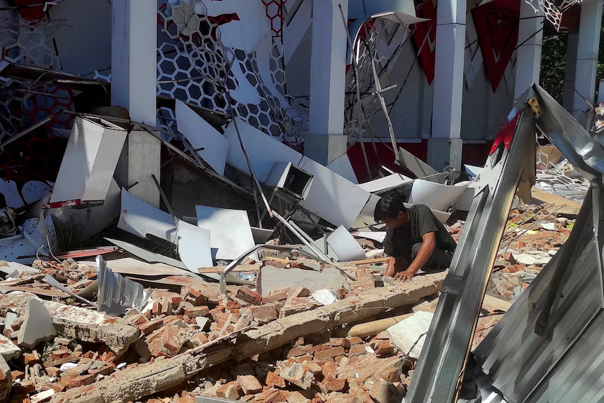
News channel Metro TV broadcast images of the destruction, showing a heavily damaged sports complex. Footage revealed rescue workers navigating through mangled wall panels, bent metallic structures, and large pieces of furniture thrown across the ground.
Initial assessments from Indonesia’s disaster management agency (BNPB) indicated minor to moderate damage to residential buildings. A church in the Batang Dua Island district sustained structural damage, along with at least two homes in South Ternate.
The ground did not settle immediately. BMKG chief Teuku Faisal Fathani reported 11 significant aftershocks, with the largest hitting a magnitude of 5.5. Reuters also noted that approximately 50 smaller tremors were monitored in the aftermath.
BNPB spokesperson Abdul Muhari urged residents to stay away from damaged buildings and beaches until the area was declared completely stable.
A Volatile Seismic History
Indonesia sits directly across the “Pacific Ring of Fire”, a seismically active belt of volcanoes and fault lines.
The Molucca Sea regularly records moderate to large earthquakes. Over the past 50 years, the USGS has recorded nine other earthquakes with a magnitude higher than seven within a 250-kilometre radius of Thursday’s epicentre.
Because many of these deep-sea quakes occur far from the coast, extensive mainland damage is often avoided.
Indonesia has paid a heavy price before. In 2022, a 5.6 magnitude earthquake ripped through West Java’s Cianjur city, killing at least 602 people.
In 2018, a quake and subsequent tsunami in Sulawesi claimed over 4,300 lives. And in 2004, a massive Indian Ocean earthquake triggered a catastrophic tsunami that killed over 230,000 people across a dozen countries, leaving the heaviest devastation in Indonesia’s Aceh province.
Data and wave modeling for this event were provided by the United States Geological Survey (USGS) and Indonesia’s Meteorology, Climatology, and Geophysical Agency (BMKG).